[BOJ 15269] Lunar Landscape
View as PDFA satellite is surveying a possible rover landing area on the moon. The landing area is modeled as a square grid embedded in the standard coordinate system.</p>
The satellite has taken n photos, each capturing a square area of the surface. Careful camera calibration has ensured that all photos are aligned with the grid — all four vertices have integer coordinates. Due to the satellite’s changing orbit there are two types of photos:
- Photos of type Ahave sides that are parallel to coordinate axes. Such a photo is specified by giving the integer coordinates (x, y) of the square’s middle point and the length of its side a — always an even integer.
- Photos of type Bhave sides at a 45◦ angle to the coordinate axes. Such a photo is specified by giving the integer coordinates (x, y) of the square’s middle point and the length of its diagonal d — always an even integer.
Find the total surface area captured in the satellite photos.
입력 형식
The first line contains an integer n (1 ≤ n ≤ 200 000) — the number of photos. The j-th of the following n lines is either of the form “A xj yj aj” or “B xj yj dj” representing a photo of type A or B, respectively. The xj and yj are the integer coordinates of the middle point of the photo (−1 000 ≤ xj, yj ≤ 1 000). The aj and dj are even integers (2 ≤ aj, dj ≤ 1 000) — the side length and the diagonal length, respectively
출력 형식
Output a number with exactly two digits after the decimal point — the total area of the surface. The answer has to exactly correspond to the judge’s solution (no rounding errors are tolerated).
예제 입력 1
2
A 0 0 2
B 1 0 2
예제 출력 1
5.00예제 입력 2
8
A -7 10 4
B 3 10 8
A -6 6 6
A -2 5 8
B 3 -1 8
B -7 -4 8
A 3 9 2
B 8 6 6
예제 출력 2
205.50힌트
Sample 1: 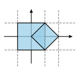 </p>
</p>
Sample 2: 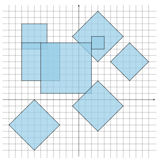
Comments